

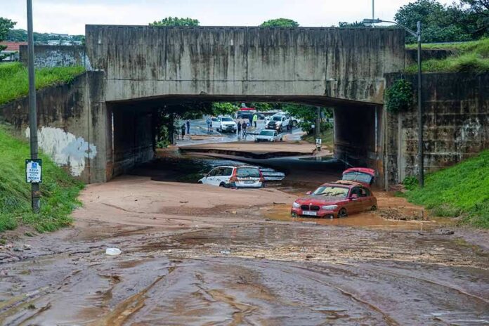
In Gulf Coast storms, water and infrastructure—not just the wind rating on a map—dictate the real stakes; Edouard proved it in Texas, where a compact tropical system drove hours of torrential rain inland, flooded roads, and cut power to tens of thousands even as its formal classification shifted while moving ashore.
At a Glance
- Edouard came ashore near the Texas–Louisiana border and tracked northwest, concentrating the worst rain and wind over Jefferson County and neighboring areas.
- National Hurricane Center guidance anticipated 3–7 inches of rain with localized 12-inch maxima, making flash flooding likely and river flooding possible across the Upper Texas Coast into east‑central Texas.
- Outages climbed quickly as trees and saturated soils brought down lines; contemporaneous tallies ranged from the tens of thousands locally to more than 80,000 statewide at peak.
- Hazards persisted well inland: slow movement and deep tropical moisture sustained flash‑flood risk into the following morning, with a brief, low‑end tornado threat embedded in rain bands.
What happened: a compact landfall with outsized water impacts
Edouard made landfall near the Texas–Louisiana line and immediately translated its Gulf moisture inland, placing the storm’s strongest rain bands over Jefferson County, including Beaumont and Port Arthur. Local broadcasts documented sustained winds near 50–60 mph with higher gusts on the immediate coast and road flooding as drainage struggled to keep up beneath the most persistent bands. As the center crossed the Beaumont–Port Arthur corridor, utility outages escalated—about 42,000 customers in Jefferson County alone were reported without electricity during the passage, with toppled trees and blocked streets consistent with a compact, fast-ramping tropical system pushing ashore on saturated ground.
The power-loss picture widened as the afternoon progressed. By nightfall, statewide outage estimates approached 82,000 customers as bands and squalls arced inland across southeast Texas; those numbers reflect the combination of coastal gusts and inland treefall common in early landfall hours before the storm’s wind field decays appreciably over land. While the classification label slipped from tropical storm to tropical depression after landfall, the practical hazards—flooded low-water crossings, localized wind damage, and sporadic communication disruptions—remained the same for residents beneath the heaviest rain axes.
Forecast backbone: why forecasters emphasized rain and flash flooding
From the outset, the National Hurricane Center framed Edouard as a rainfall-driven event for Texas. Advisories called for 3 to 7 inches across the Upper Texas Coast into east‑central Texas, with pockets up to 12 inches where slow-moving bands repeatedly trained over the same communities; the text was unambiguous that flash flooding was likely and significant flash flooding possible, with a secondary risk of river flooding as catchments responded to multi‑inch totals in short windows. That guidance also flagged a brief tornado potential across southeast Texas and southwest Louisiana—a familiar, low-visibility threat in the outer rain bands where friction and shear can stretch spin into shallow, fast-moving circulations.
Local statements from the Houston/Galveston weather office aligned with the national advisory suite: Edouard’s center was inland, the motion projected northwest across East and Southeast Texas, and scattered power and communications outages were anticipated as squalls worked through. The watch/warning package reflected the inland emphasis, prioritizing flash flooding over storm surge as the center moved past the coastal marshes into the Piney Woods. Taken together, the forecasts communicated the right hazard hierarchy for Texas: expect water problems first, then manage localized wind damage and brief tornadoes on the periphery.
Mechanism: how a “small” tropical cyclone overwhelms local systems
Edouard’s impact profile fits a recurring Gulf Coast pattern. Warm, high‑octane shelf waters prime convection; once the core consolidates and comes ashore, a tight pressure gradient and deeply saturated column wring out rainfall efficiently. With forward speed modest and banding locked to the storm’s northeast quadrant, the same neighborhoods can sit under two‑inch‑per‑hour rainfall for successive bursts—more than enough to overwhelm urban drainage, low‑lying bayou crossings, and rural ditches. Trees rooted in saturated soils then fail under gusts that, on paper, may seem unremarkable. The power grid’s vulnerability is more about exposure geometry—long spans, fringe limbs, and backyard drops—than about whether the advisory winds are 40 or 60 mph. That is why outage maps often mirror rain footprints rather than the storm’s official peak gust plot.
Inland, small river basins and tributaries respond quickly. Even where mainstem rivers need longer to crest, the flash‑flood problem unfolds on road networks, underpasses, and bayou-adjacent neighborhoods in a matter of hours. NHC guidance captured this, warning that heavy rain and flash flooding would persist through Thursday morning across the Upper Texas Coast and into east‑central Texas as Edouard tracked inland.
Classification vs. consequences: why the label didn’t change the outcome
One source of public confusion with Edouard was nomenclature: some reports referenced a tropical storm at landfall, others a tropical depression later in the period. The switch is meteorologically routine—systems weaken over land as their oceanic heat engine is cut off—but immaterial to the hazards that matter most to households. Advisories and discussions consistently emphasized continued heavy rain and flash flooding while the circulation moved inland, regardless of whether sustained winds sat just above or just below the 39‑mph tropical‑storm threshold. The embedded tornado note likewise remained valid through the evening for southeast Texas and adjacent Louisiana. In other words, water risk persisted while the nameplate intensity stepped down.
For grid operators, emergency managers, and residents, that distinction is academic. Line crews restore circuits branch by branch; responders manage high‑water rescues and barricade flooded crossings; families navigate outages and localized road closures. Edouard delivered each of those stressors in sequence, with documented outages in Jefferson County and a statewide tally escalating into the tens of thousands as bands pulsed west and north from the Sabine–Neches corridor.
2/16 🇺🇸 N.AMERICA — Tropical Storm Edouard made landfall near Johnson Bayou, Louisiana at 2:20 p.m. CDT Tuesday with 60 mph sustained winds and a 71 mph gust recorded near the Texas border. Now weakened to a tropical depression, it continues to bring flash flooding across…
— The Syndicate (@SyndicateRSS) September 2, 2026
What to watch in the aftermath: verification, rivers, and recovery tempo
Two clocks run after a landfall like Edouard’s. The first is hydrologic: as urban runoff drains and soils stay saturated, smaller basins fall quickly, but larger rivers—Neches, Trinity, San Jacinto headwaters—can reflect upstream rain with a lag. That is where “river flooding possible” in the advisories earns its nuance; the crest risk extends beyond the last downpour. The second is operational: outage restoration typically scales from critical infrastructure outward, meaning hospitals, water plants, and major feeders see early work before residential laterals. With peak statewide outages reported near 82,000, the restoration curve is measured in hours to a few days for most customers, barring concentrated windfall corridors that require rebuilds.
From a forecasting perspective, Edouard will be folded into best‑track and verification analyses—the post‑event process the National Hurricane Center uses to benchmark track and intensity guidance against what actually occurred. That machinery exists precisely because real‑time snapshots often overweight the most dramatic locations; post‑analysis synthesizes observations to fix the storm’s official record, which in turn sharpens future forecasts of systems like Edouard that present as compact, rain‑centric Gulf events.
Bottom line
Edouard’s Texas chapter was defined by rain and the cascading infrastructure effects that follow: flooded roads, scattered tree and line damage, and fast‑rising outage counts. Forecasts were clear about that risk profile ahead of landfall, and the unfolding impacts matched the guidance—particularly across Jefferson County and the inland track toward east‑central Texas. For Gulf Coast communities, the lesson is enduring: do not anchor your decisions to a storm’s label; calibrate them to the water it will put on your street and the time it will take your grid to dry out.
Sources:
washingtontimes.com, accuweather.com, nhc.noaa.gov